1/8
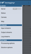
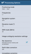
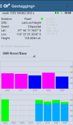
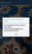
Geotagging+ screenshot 0
Geotagging+ screenshot 1
Geotagging+ screenshot 2
Geotagging+ screenshot 3
Geotagging+ screenshot 4
Geotagging+ screenshot 5
Geotagging+ screenshot 6
Geotagging+ screenshot 7
Geotagging+ Icon

Geotagging+

Nuaim Hammad Ausi
Trustable Ranking IconPouzdano
1K+Preuzimanja
17MBVeličina
Android Version Icon4.0.1 - 4.0.2+
Android verzija
1.1(29-06-2018)Najnovija verzija
-
(0 Prikazi)
Age ratingPEGI-3
Preuzmite
DetaljiPrikaziVerzijeИнфо
1/8

Opis aplikacije Geotagging+

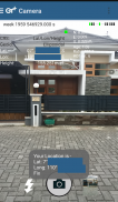
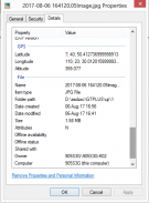
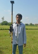
This app allows you to take image and measure with low-cost GNSS module (like U-blox GNSS module or E-GNSS from potretudara : http://www.potretudara.com/low-cost-gps-gis/ ). Measured coordinates from low-cost GNSS module are stored to EXIF image metadata in time when you tap the "capture" button. Use this to create your geotagging more precise to sub-meter level. Very useful for census, GIS support, reporting issue, and others.


You can still use internal GNSS for geotagging by deactivate BASE and ROVER in the Input Stream menu. Obviously none of the precision algorithm found in RTKLIB can be use.


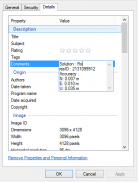
Image taken by this app will have coordinate metadata, accuracy, and solution type (internal, single, float, or fix).


Heavily based on RtkGps+ from Ronan LE MEILLAT, this is a fork of his work. Original licenses are in the "About/Legacy Info" screen. Thanks to all contributors to respect this clause.


This app is RTKGPS+-like with additional Camera menu. You still can use this app for surveying, tracking, etc. like RTKGPS+ do.


This app is a port of RTKLIB 2.4.3b 28 developed by Tomoji Takasu (http://http://www.rtklib.com/). This RTKLIB 2.4.3 is modified by rtklibexplorer and named RTKLIB 2.4.3 demo 5 b 28 (https://github.com/rtklibexplorer/RTKLIB). If you do not know what this application is, this application is probably not what you are looking for!


App manual : http://bit.ly/shortmanual

Geotagging+ - Verzija 1.1

(29-06-2018)
Druge verzije
Šta je novo* Merge to RTKLIB demo 5 b 28 (update rtklibexplorer 5/8/2017)* Add Height-metadata on photo taken* Fix solution-metadata (internal/single/float/fix) on some devices* Fix input negative LLH/ECEF coordinate base station position

Trenutno nema komentara ili ocena! Da biste ostavili prvi komentar ili ocenu,

-
0 Reviews
5
4
3
2
1

Geotagging+ - Informacije o APK datoteci

Verzija APK datoteke: 1.1Paket: com.geotaggingplusfree
Kompatibilnost sa Android sistemom: 4.0.1 - 4.0.2+ (Ice Cream Sandwich)
Programer:Nuaim Hammad AusiSmernice za privatnost:https://github.com/ausiozDozvole:12
Naziv: Geotagging+Veličina: 17 MBPreuzimanja: 7Verzija : 1.1Datum objavljivanja: 2018-06-29 18:52:35Najmanji ekran: SMALLPodržana CPJ: x86, armeabi, armeabi-v7a, mips
ID paketa: com.geotaggingplusfreeSHA1 potpis: F8:CE:A3:16:6D:39:C8:BD:54:40:88:1D:00:FA:C3:DF:1A:F9:16:9CProgramer (CN): Nuaim Hammad AusiOrganizacija (O): Lokacija (L): Zemlja (C): Država/grad (ST): ID paketa: com.geotaggingplusfreeSHA1 potpis: F8:CE:A3:16:6D:39:C8:BD:54:40:88:1D:00:FA:C3:DF:1A:F9:16:9CProgramer (CN): Nuaim Hammad AusiOrganizacija (O): Lokacija (L): Zemlja (C): Država/grad (ST):

Poslednja verzija aplikacije Geotagging+

1.1Trust Icon Versions
29/6/2018
7 preuzimanja17 MB Veličina
Preuzmite